Candida Martinelli's Italophile Site
Main
Page This family-friendly site celebrates Italian culture for the enjoyment of children and
adults. Site-Overview
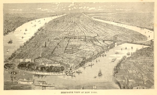
New York City circa 1885. New Jersey on
the left, and Brooklyn on the right. You can see Battery Park at the lower end of Manhattan
Island, and the Brooklyn Bridge, which was completed in 1883, joining
New York City to the fastest growing city in the U.S. at that time,
Brooklyn. It was hoped Brooklyn would ease the
over-crowding in New York City, but it was a false hope. Both
cities grew at rapid rates fueled by tremendous rates of
immigration. The tenements that blighted New York, blighted
Brooklyn too. However, it was in Brooklyn that new model
tenements were built with much success, improving living conditions
for the working poor. In this era before sky-scrapers, it is church
steeples that jut above the sky-line across the island, from many
different denominations and language groups. Ferries, many seen in the image, carried
commuters, business people and tourists across the rivers and to and from the
islands in the rivers, which housed criminals, the insane, paupers,
and the dead in a cemetery. Goods were brought into the city via ships and
barges, seen docked along both sides of the island and in Brooklyn, and via the
railroad that ended at Grand Central Station near the geographic
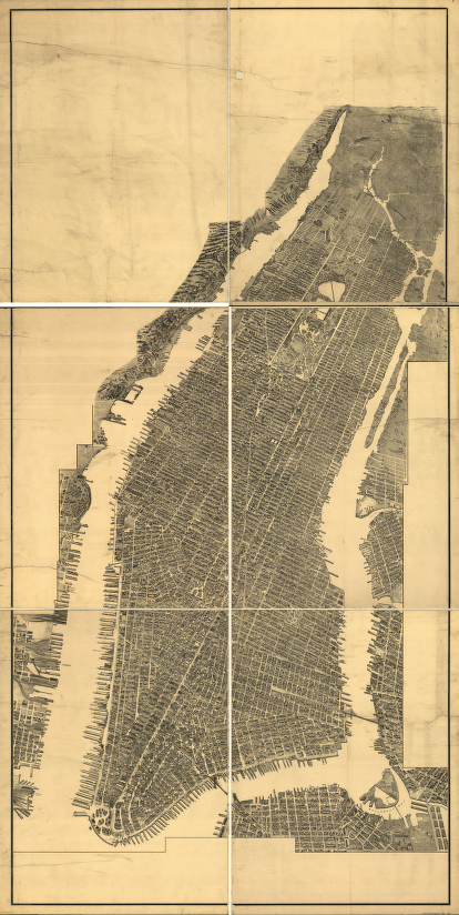
center of the island. New York City circa 1905. You can see Central Park, which was built from
1857 to 1878, and improved upon since, principally with the addition
of sports facilities, absent from the original park designs. In
those days, parks were designed to recreate nature outside of cities,
not to provide physical activity for the sedentary modern office
worker and city-dweller. Click here
to read more about Central Park. The two bridges are Brooklyn Bridge, completed
in 1883, and the Williamsburg Bridge, completed in 1903. Click here
to read more about the bridges of New York. Look closely, and you'll see that rural New York
began roughly where Central Park ended. This image is from the U.S. Library of Congress
and is actually of a draftsman's drawing of incredible detail.
At their website,
you can zoom into any area of the drawing to view the amazing
representations of elevated railways, streets, tram tracks, parks,
building facades, ships...
![]()

Two
Views of New York City from
1885 and 1905
![]()